Preserving and protecting the environment and promoting resource efficiency.

Protecting and promoting natural and cultural resources
The main goal of the VISFRIM project was to support an efficient management of hydraulic risk in cross-border basins by developing methodologies and technological tools functional to the implementation and update of existing Flood Risk Management Plans (FRMPs).
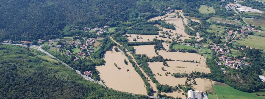
The programme area is vulnerable to floods and this trend is tragically set to increase in future due to the ongoing intense urbanisation process and climate change. The VISFRIM project consequently originated to support an efficient management of hydraulic risk in cross-border basins. For this purpose, the initiative involved governmental bodies and local authorities, so to take into account different points of view and interests related to the theme of floods. In detail the eleven partners collaborated in various activities carried out in the international basins of the Isonzo and Vipacco rivers and in the interregional basin of the Lemene river, which allowed to update the picture of the hydraulic hazard in the examined territories.
The main outputs achieved by the project are listed below:
For more information, it is possible to view the reports available in the "Project documents" section of the website.
Lead Partner

Project partner 1

Project partner 2
Project partner 3

Project partner 4
Project partner 5
Project partner 6
Project partner 7

Project partner 8

Project partner 9
Project partner 10

| VISFRIM project poster VISFRIM project poster.pdf ( 1 byte, published on 20 March, 2023 - 10:02 ) | |
| VISFRIM Brochure VISFRIM_Brochure.pdf ( 2 bytes, published on 20 March, 2023 - 10:02 ) | |
| VISFRIM roll-up VISFRIM roll-up.pdf ( 1 byte, published on 20 March, 2023 - 10:02 ) | |
| VISFRIM promo material Promo_material.pdf ( 10 bytes, published on 20 March, 2023 - 10:02 ) | |
| Hydraulic modelling of the Lemene catchment WP3.1_Lemene_flood_modelling.pdf ( 12 bytes, published on 22 March, 2023 - 09:07 ) | |
| Installation of stream gauges inside the Lemene catchment WP3.1_Lemene_gauging_stations.pdf ( 6 bytes, published on 22 March, 2023 - 09:07 ) | |
| Technical Report about topographical surveys performed inside the Vipava and Lemene river basins WP3.1_Topograhical_surveys.pdf ( 10 bytes, published on 22 March, 2023 - 09:07 ) | |
| Guidelines for transboundary UAS operations WP3.1_Transboundary_UAS.pdf ( 2 bytes, published on 22 March, 2023 - 09:07 ) | |
| Hydraulic modelling of the Vipava river WP3.1_Vipava_flood_modelling.pdf ( 3 bytes, published on 22 March, 2023 - 09:07 ) | |
| Development of an IT platform for the elaboration of Flood Risk Maps and cost-benefit analysis of Flood mitigation measures WP3.2_Cost_benefit_analysis.pdf ( 3 bytes, published on 22 March, 2023 - 09:07 ) | |
| Technical Report - Project documentation for Vipava Municipality WP3.2_Flood_mitigation_studies_Vipava.pdf ( 2 bytes, published on 22 March, 2023 - 09:07 ) | |
| Technical Report about the regulation of navigation activities along the Vipava river in the municipality of Nova Gorica WP3.2_Navigation_study_Nova_Gorica.pdf ( 1 byte, published on 22 March, 2023 - 09:07 ) | |
| Technical Report about the Citizen Observatory – Lemene case study WP3.3_CO_Lemene.pdf ( 1 byte, published on 22 March, 2023 - 09:07 ) | |
| Technical Report about the Citizen Observatory - Soča WP3.3_CO_Soca.pdf ( 2 bytes, published on 22 March, 2023 - 09:07 ) | |
| Investments WP4_Investments.pdf ( 10 bytes, published on 22 March, 2023 - 09:07 ) |


")
")
")
")
")


")
.")
.")


")
")


.")


")
")
")
")
")


The specific objectives of the project were:
For these purposes, the following tasks were carried out:
This deliverable is intended to provide a practical guideline outlining the ordinary procedures that can be adopted for transboundary UAS operations, namely operations that involves Unmanned Aircraft Systems flying across the border between Italy and Slovenia. The twofold advantages resulting from transboundary UAS operations within the scope of the VISFRIM project are: improving flood modelling through transboundary-continuous digital terrain models, rather than national, border-cut digital terrain models; supporting environmental monitoring, such as for mapping of flooded unurbanized territories.
The topographical survey of nineteen river cross sections was planned on the Vipava river. In detail the survey campaign was linked to a previous one, performed on the Isonzo river in 2014 during the Interreg CAMIS project, and the levelling line from the Gradisca bridge was extended until the state border.
In addition an altimetric support network was defined on the Lemene river basin for the subsequent survey of 430 river cross sections. Specifically, 112 new leveling benchmarks were defined, 35 of which constitute the new connecting line between Pordenone and Portogruaro. Starting from the abovementioned levelling line, further high precision surveys were extended also towards: hydrometric stations installed inside the Lemene catchment; some monitoring sites managed by the Veneto Orientale Land Reclamation Consortium.
Eastern Alps River Basin District (AAWA) worked to the installation of two new stream gauges inside the Lemene basin, whose records are intended:
Several hydrological and hydraulic modelling activities were performed for the Vipava river, based on which agreed consensus was reached between the two involved water authorities (Slovenia: DSRV; Italia: AAWA), which is that 100-year return period discharge at the Italian-Slovenian border is estimated to be in the range between 480 m3/s to 600 m3/s. This uncertainty will be reduced in future with greater number of hydrometric observations and updating of hydrological analysis by Slovene counterpart.
Various hydraulic modeling activities were carried out for the Lemene basin. First achieved results were encouraging and pointed out the need of broadening existing knowledge by: the installation of new gauging stations; the realization of surveys and meetings with local stakeholders, aimed at collecting useful information about hydraulic criticalities; the realization of numerous topographical activities to update the geometry of the river system.
Modeling activities, implemented in the project VISFRIM, will continue in next months with the aim of updating the picture of the hydraulic hazard for the entire basin.
Internal staff from Eastern Alps River Basin District (AAWA) elaborated and shared a report about methodologies for flood risk mapping and cost-benefit analysis of mitigation measures, based on which one IT platform was later developed.
Veneto region ordered the realization of a series of surveys on some river levees located in the southern portion of the Lemene River Basin and the successive elaboration of possible intervention proposals, including cost’s estimation.
For selected areas in the municipality of Vipava, hydrological and hydraulic analysis were prepared by external consultants about the implementation of flood mitigation measures. Descriptions are given for all measures, including the basic characteristics of the proposals (dimensions, geometry, location, etc). All the proposed measures aim to improve flood safety in selected areas, while minimally interfering in the watercourse riverbeds, thus preserving the habitats and morphology of existing watercourses.
The elaborated study is the basis for determining the necessary order of priority of flood protection measures and to apply for building permit.
The Municipality of Nova Gorica ordered the elaboration of technical documentation for the regulation of navigation along the Vipava river. It analyses the subject area and external factors that can affect the possibility of navigation, included river flooding. This analysis is the basis for: planning navigation activities and its regime; determining the navigation area and entry/exit points. As such, the document represents the professional basis for the preparation of the local community's act on navigation in the area of the municipality.
The activities included in this WP are aimed at implementing a Citizens’ Observatory inside the case studies of the project, through which a greater involvement of population in water governance processes could be achieved by exploiting the potential of green Information and Communication Technologies (ICTs). Specifically this report refers to the activities performed in the Italian (Lemene catchment) and Slovene case study (Isonzo catchment): raising awareness activities and requirements specification; design of the software architecture and prototyping; implementation of a Citizens’ Observatory in the pilot and analysis of citizens' feedback.
The structural interventions were designed in order to reduce the environmental impact, while still guaranteeing the necessary protection from flooding. In particular, natural and sustainable materials were used (local wood and stones) and existing infrastructures were recovered, where possible and economically convenient.
For more information, it is possible to view the reports available in the "Project documents" section of the website.
Operation co-funded by the European Regional Development Fund