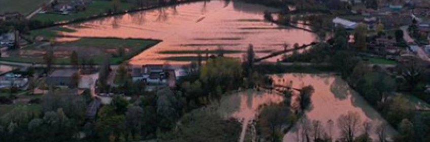
The Lemene basin is located in northern Italy and covers an area of 1018 km2over the Veneto and Friuli Venezia Giulia (FVG) regions. It is delimited from the east by the Tagliamento river, from the west by the Meduna and Livenza rivers and from the south by the Caorle lagoon (Fig. 1).This transboundary basin is of high interest since, unfortunately, it has been frequently subject to flood events, the most recent one occurring in November 2019 (Fig. 2).
In order to setup the Lemene hydrological and hydraulic model, spatial and hydro-meteorological data have been collected. A brief description of such information is presented below:
| Data type | Source | |
| Spatial data | River cross-sections |
|
| DTM (Digital Terrain Model) |
|
|
| Hydraulic issues / flood extents |
|
|
| Hydro-meteorological data | Sea tides | ISPRA |
| Precipitation and stream level data from existing gauges |
|
|
| Stream level data from recently installed gauges | Data derived from the two new hydrometric stations, installed in November 2019 thanks to the VISFRIM project’s funding |
In order to facilitate data sharing among technical project partners and to support public consultation of flood-related information, the following steps were taken:
The hydrographic network from the Hydrogeological Structure Plan (PAI) for the Lemene catchment was considered as a reference for the development of a new hydraulic model, including, however, more recently acquired topographical data. In detail, in order to facilitate the import of raw geometrical data into the hydraulic model, different codes were developed, allowing for a more fluent and speedy inputting process.
The 1D modelling of the entire PAI hydrographic network was completed (Fig. 4), as well as the 2D modelling of potentially flooded areas.
In the upcoming months, the following activities are programmed:
 | Lemene river network Fig. 1.png ( 455 bytes, published on 17 May, 2021 - 11:28 ) |
 | Floods occurred at Colle, Azzano Decimo, in November 2019 Fig. 2.png ( 115 bytes, published on 17 May, 2021 - 11:28 ) |
 | Screenshot of the WebGIS, created in Lizmap, showing the different information layers presently available for the Lemene basin Fig. 3.png ( 81 bytes, published on 17 May, 2021 - 11:28 ) |
 | The Lemene hydraulic model under development Fig. 4.png ( 310 bytes, published on 17 May, 2021 - 11:28 ) |
Operation co-funded by the European Regional Development Fund